
WELL, THIS IS ONE FOR THE BOOKS. Hands down, the most "adventurous" part of the trip so far, and hopefully nothing else will compare for the remainder. Yesterday we had a session in the afternoon in Tennessee. Three dancers arrived, and we hiked out to the Twin Arches area of Big South Fork National River and Recreation Area. Beautiful hike, .7 miles each way. Once we got back to Buford and their cars, we decided to go to the other area called out on our permit, Honey Creek.
We arrived at Honey Creek at about 6:30 pm, with sunset due to happen by 8:10pm, I figured we had about two hours left of hiking time. So we found the map, got some photos of it for reference, and headed down the trail. The map said it was about a mile down to the falls, and less on the way back. Little did we know, the sign lied.
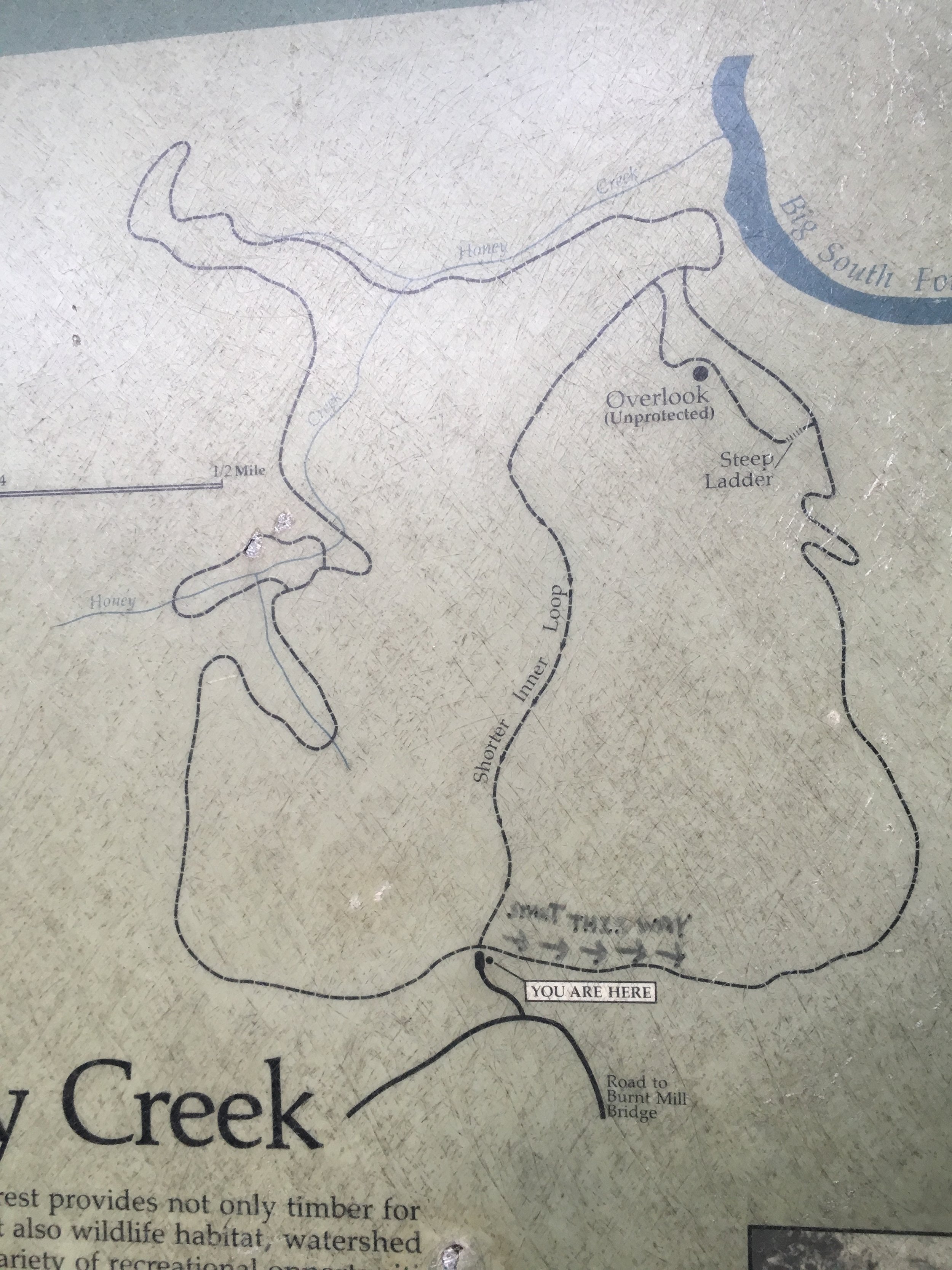
First, the sign lied when it said "You are Here". The sign saying this was nowhere near the actual head of this trail. So while we though we were headed out onto the trail to Honey Creek and its waterfall / Overlook, what we actually got onto was the John Muir Trail. Here is the description of the trail we ACTUALLY went on -
For those wishing to escape from mankind and lose (or find) themselves in the wild forests of the Cumberland Plateau, the John Muir Trail—named after one of this country's most famed outdoorsmen—is a great place to "keep close to Nature's heart and break clear away," as he would say.
Hikers should be warned, though, this is not a well-maintained trail like you might find in the Smokies. While some developments have been made to the park in recent years, hikers should still be prepared to ford rivers, camp in imperfect sites, and generally improvise along their way north. We’d also suggest buying a good, topographical map of the area and a guidebook like Hiking the Big South Fork by Deaver, Smith, and Duncan. Permits are required and can be found here.
Marked by the blue, bearded silhouette of its namesake, the John Muir Trail meanders for 44 miles through Big South Fork and requires about 5 days for most hikers to complete. Sign in at the Brandy Creek Visitors Center before setting out on this long expedition. Starting at the south end, hikers are advised to to park in the relatively well-lit Leatherwood Ford parking lot to avoid theft while on the trail. From Leatherwood Ford, you’ll head north to the Angel Falls overlook and continue along the west side of the Cumberland River before following the trail northwest away from the river, across Chestnut Ridge to the John Muir Overlook. Cross the Big South Fork boundary into Pickett State Park and finish at the trailhead for Hidden Passage Trail, where your second car should be parked.
We had no clue what we were in for. As we hiked down to the falls (or so we thought), the "trail" went from a trail to some serious bouldering and rather obscure paths. However, we did follow the trail markers, so we knew (HA!) we were still on the trail. In about 40 minutes, we got down to a waterfall, which we thought was the falls at Honey Creek. While the area was rugged and gorgeous, it was not much in the way of a waterfall. But we got our images in about 20 minutes, and then headed back out. Instead of retracing out steps, we did what I thought was the straight line return trail in the middle of the maps. This is where the adventure really began.
I did not mention that three dancers all brought someone with them. Hailey brought her mom Rana, Chloe brought her mom Amber, and Darbey brought her boyfriend Chaz, as well as their dog Capone. When I say dog, I mean Mac Truck. This 9 month old American Pitfall Terrier weight 120 lbs, AND IS STILL GROWING! Such a sweetheart, though, and very well behaved.
We began our hike back, and after the the first couple minutes, we got to what I thought was the "steep ladder" part on the map. It was a rope, that you needed to pull yourself up with along a rock face. We all made it up (the puppy was a rockstar!) and we were off and running.
But the trail kept going, and going, and going. And it got rougher. We were sliding through caves, crossing streams, oh, and the bugs! Particularly the spiders. I was leading, and the trail had not been hiked in quite a while, so it was both overgrown and COVERED WITH SPIDER WEBS!!! Which I removed for everyone by using my face. =(
It was now dark, and we should have made it back to the cars, but we pressed on. We were still following the trail markers, so we THOUGHT we were still in the right place, and looking at google on our phones (no service, but the GPS was tracking still) we were almost at the road. However, the "road" Google showed us was no longer a road, it was now a horse trail. We found a sign, calling out mileages, but nothing was anywhere close to us. I suddenly had on bar of service, and decided to call the cavalry.
"911 - what is your emergency?"
"Hi, we're hiking, and seem to be lost, although we are still following the trail markers, we have gone much further than we should have needed to. Can you help?"
After about 30 minutes of chatting with the dispatcher, we finally got a Park Ranger connected to us. He told us that to get out, we would still have to hike 1.7 miles out to the O&W Bridge. It's a new trail, not on any map. And, considering the terrain and darkness, it would take us about 90 minutes to complete. And this is nowhere near our cars, so they would meet us there and drive us back around to where we parked.
Now, we did have flashlights. I brought three with me - two epic bright ones, and my headlamp. Thank goodness for that! Darby and Chaz had a couple as well, and everyone had cell phones. So, at 10:15pm, we began our hike out.
Did I mention we were soaked from sweat, tired, and pretty much everything hurt at this point? So with packs full of tutus, dance clothes, and camera gear, we headed out.
Along the way, we ran into snakes, MANY more spiders, but this trail was much nicer. Downhill, and actually a trail, as opposed to what we had been on. At least, until the last half mile or so. We lost the trail.
As we hiked, the markers vanished, and the terrain got really rough again. Very steep downhills, slippery rocks, streams, and my guess as to what the trail was supposed to be. But, as it turns out, we guessed right. We had some great teamwork, with Chaz and Darbey taking the lead down with one of my big lights, and I took up the rear, making sure to keep everyone together with no mishaps. We finally saw headlights.
When we got up to the road, there were 10 vehicles from the Scott County Rescue Squad, the park ranger, and the Sheriff as well. We had now hiked a total of 11.52 miles that day. 1.5 miles of that was from our first location. But from 6:30 pm to 12:15 am, we hiked 10 miles of some of the most difficult, brutal, and obscure trails I have even been on in my life. And now had to ride back to Buford. That ride took 26 miles, and almost an hour.
So, in the end, we finally made it back to the vehicles at around 1:15am. Some blisters, sore knees and ankles, but safe, and in good spirits. This was, without a doubt, the hardest photoshoot I will have ever have attempted. I have not even looked at the images from yesterday yet, but there is some gold in there. There better be, after all of that, right?!?
Thank you to the Scott County Rescue Squad, Scott County 911 dispatch, Ranger Gary (never got his last name) and the Scott County Sheriff's Department for helping us out. Thank you T-Mobile for actually working when I needed you most. And thank you to my intrepid team, the DATUSA dancers for Big South Fork. You are THE most extreme people, and you made it through a very difficult situation with grace and composure.
Now, it's off to Ohio to prepare for the sessions tomorrow. Sunrise at Blue Hen Falls, with another hike. But this one is only .5 miles, and is well marked. Or so it says... duh, Duh, DUHHHHHHH!!!!!!
Jonathan, out.

Our dancers, the puppy, and Scott County Rescue.